
Understanding Landslip Risk Assessments in Australia: When Do You Need One?
Learn when a landslip risk assessment is required in Australia. Understand slope stability inspections, hillside property risks, erosion triggers, and council compliance requirements for safe development.
Introduction
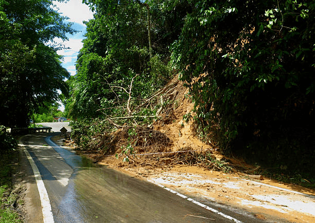
Landslip risk is a major concern for anyone dealing with hillside or sloping land in Australia. Slopes behave differently from flat sites and can shift, settle, or collapse when conditions change. In recent years, higher rainfall and ongoing erosion have increased slope failures across NSW and Victoria. This makes early assessment even more important.
Homebuyers, councils, architects, engineers, and developers all rely on landslip risk assessments to make safe choices. These assessments guide design, earthworks, foundations, and drainage. They also help prevent long-term damage. Geoslope provides fully certified slope stability investigations to support projects from start to finish.
In this guide, you will learn what a landslip risk assessment is, why it matters, when you need one, and how Geoslope carries out the full process. The aim is to give you clear and simple information so you can make safe decisions.
What Is a Landslip Risk Assessment and Why It Matters
A landslip risk assessment is a detailed study of a slope and its behaviour under natural or man-made conditions. It helps identify how stable the ground is and what may cause movement. The goal is to protect people, properties, and projects. The findings guide builders and homeowners so they can plan safe construction and avoid major issues.
What the Assessment Evaluates
A landslip assessment looks at the full picture of a slope. It studies slope geometry and signs of ground movement. It checks the soil type, water content, and erosion patterns. It examines vegetation cover and drainage paths. It reviews the effect of structures on retaining walls and footings. It also looks at the history of landslides or any past instability.
Slope shape and surface movement
Soil and moisture behaviour
Drainage and erosion patterns
These checks help engineers understand how the slope may behave over time.
Key Signs of Slope Failure to Watch For
Some signs show that a slope may be unstable. These signs should not be ignored. Cracks may appear in soil or on the ground surface. Retaining walls or fences may begin to lean. Floors inside homes may become uneven or doors may stick. Water may pool on the slope or runoff may increase. Erosion can appear suddenly after rainfall.
Cracks in the ground
Leaning walls or fences
Water issues on the slope
If you see these signs, a slope stability assessment is needed. Early checks reduce the risk of sudden failure.
When You Need a Landslip or Slope Stability Inspection
Landslip assessments are often required during planning or development. They are also needed when land shows concerning signs. They help meet council rules and protect new structures.
Triggers That Require an Assessment
Some events or conditions clearly indicate the need for a slope stability inspection. You may need one when buying or developing a hillside property. Councils may require one as part of the DA process for sloping land. Many areas have overlays for landslip zones and these zones require mandatory assessment. New retaining walls or major upgrades usually need geotechnical checks. Evidence of erosion, moisture buildup, or ground movement is also a strong trigger. After a major storm or heavy rainfall, a post-storm inspection may be required to confirm safety.
Buying or developing on a slope
Areas marked as landslip zones
Retaining wall projects
These triggers help prevent unsafe builds or structural failures.
What Councils Commonly Require
Most councils across NSW and Victoria have clear rules for hillside development. They require geotechnical slope stability modelling. They ask for a full soil and rock profile assessment. They need certification that confirms a safe building envelope. They also want recommendations for earthworks, drainage, and retaining wall design. The assessment must follow Australian Standards and local planning requirements.
These checks allow councils to approve only safe designs. This protects communities and reduces future landslip risk.
How Geoslope Conducts a Professional Landslip Risk Assessment
Geoslope uses a detailed and structured process for slope investigations. This ensures that every slope is assessed with care and accuracy. It also ensures that all reports meet council and engineering standards.
On-Site Slope Stability Inspection
The process begins with a site inspection. A geotechnical engineer visits the property and walks over the slope. The engineer checks the surface for movement, drainage issues, and vegetation conditions. They study the shape of the slope and look for failure patterns. They also identify hazards that may affect people or structures. This on-site inspection provides vital information before deeper investigation begins.
Subsurface Investigation and Testing
Next, Geoslope carries out subsurface testing. Boreholes or test pits may be used depending on the slope and access. Soil samples are taken to check soil strength and moisture behaviour. Groundwater levels are also measured. The engineer logs changes in soil and rock layers that may influence slope stability.
These tests help predict how the slope will react to rainfall, excavation, or construction loads. They also guide decisions about earthworks and retaining wall design.
Geotechnical Slope Modelling and Risk Rating
After fieldwork and testing, Geoslope uses specialised software to model slope behaviour. The model simulates movement under different conditions such as rainfall or excavation. It assesses how added structures like retaining walls or driveways may affect the slope. The model gives a clear risk rating and identifies the likelihood of landslip.
This analysis provides strong evidence for design teams and councils. It makes it easier to plan safe building zones and protective measures.
Certified Geotechnical Report for Councils and Design Teams
The final step is a certified geotechnical report. This report includes full stability analysis. It provides risk mitigation measures such as drainage improvements or retaining wall requirements. It explains construction restrictions or safety notes. It guides architects, engineers, and builders during design and construction.
The report is certified for council approval and meets all local and national requirements. It is clear and easy to use for planning and building decisions.
Why Landslip Assessments Protect Properties, Projects and Councils
Landslip risk assessments play a major role in protecting people, homes, and public infrastructure. They help prevent structural damage and costly repairs. They reduce the chance of slope failure during or after construction. They ensure compliance with council rules, which prevents delays in approval. They improve drainage and long-term performance of the slope. They give design teams safe boundaries so they can create strong and durable structures.
Key Benefits
Reduced risk of slope failure
Safer construction planning
Better drainage performance
These benefits support long-term stability and cost savings.
Conclusion
Landslip risk assessments are vital for anyone buying, approving, or developing hillside land in Australia. Slopes across NSW and Victoria face greater stress due to heavy rainfall and erosion, which increases the chance of ground movement. A professional geotechnical assessment identifies risks early, guides safe design, and ensures compliance with planning rules. This makes it possible to prevent damage, protect investments, and create safe living spaces. Geoslope provides certified slope modelling, risk analysis, and clear design recommendations so your project can move ahead with confidence and safety.
For professional geotechnical support, contact us.
FAQs
Do all sloping sites in Australia need a landslip risk assessment?
Not all sloping sites need one. Many hillside developments and areas with landslip zoning do require a formal assessment for council approval.
What causes most landslips in NSW and Victoria?
Heavy rainfall, poor drainage, erosion, excavation, and unstable soil layers are the most common triggers. These factors weaken slopes and increase movement.
How long does a slope stability inspection take?
Most on-site inspections take one to two hours. Modelling and reporting usually take five to ten business days.
Can a landslip risk assessment stop a construction project?
Only if the risk is severe and cannot be managed. In most cases, engineers design safe drainage systems, retaining solutions, or foundation upgrades.
Does Geoslope provide certified landslip reports for council DAs?
Yes. Geoslope provides fully certified geotechnical landslip assessments that comply with NSW and Victoria council requirements.